-
Schaden & Unfall
Schaden & Unfall ÜberblickRückversicherungslösungenTrending Topic
Schaden & Unfall
Wir bieten eine umfassende Palette von Rückversicherungslösungen verbunden mit der Expertise eines kompetenten Underwritingteams.
-
Leben & Kranken
Leben & Kranken ÜberblickUnsere AngeboteUnderwritingTraining & Events

Leben & Kranken
Wir bieten eine umfassende Palette von Rückversicherungsprodukten und das Fachwissen unseres qualifizierten Rückversicherungsteams.
-
Unsere Expertise
Unsere Expertise ÜberblickUnsere Expertise

Knowledge Center
Unser globales Expertenteam teilt hier sein Wissen zu aktuellen Themen der Versicherungsbranche.
-
Über uns
Über uns ÜberblickCorporate InformationESG bei der Gen Re

Über uns
Die Gen Re unterstützt Versicherungsunternehmen mit maßgeschneiderten Rückversicherungslösungen in den Bereichen Leben & Kranken und Schaden & Unfall.
- Careers Careers
Did you Know? A Brief Reflection on La Niña and El Niño

26. August 2024
Luis Rayes,
Felipe Campana
English
The effects of La Niña and El Niño have been extensively researched and documented, particularly considering the recent extreme weather events. However, when it comes to the information you have read or been told, would you be able to answer the following questions: Can we establish a correlation between El Niño / La Niña and the occurrence of specific natural catastrophes? What major historical events have been observed and, when and where did they occur? What is the future forecast? How can the insurance/reinsurance industry cope with future disasters in years of La Niña or El Niño?
This article presents an overview of the El Niño and La Niña phenomena. With a focus on Latin America, the article outlines their effects and some of their devastating impacts on weather events. Those in the insurance and reinsurance industry would be wise to stay attuned to the power and peril of these recurring climate phenomena.
What are El Niño and La Niña?
El Niño and La Niña are global climate phenomena caused by cyclical changes in the water temperature of the Pacific Ocean. The National Oceanic and Atmospheric Administration’s (NOAA) operational definition of the phenomena starts with the most basic characteristic: The climate events occur when “seasonal temperatures [are] 0.5°C warmer (El Niño) or cooler (La Niña) than average in the central tropical Pacific.”1
Graphical Depiction of El Niño / La Niña Regions – La Niña / El Niño Tracking2
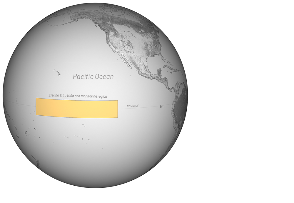
For real-time La Niña / El Niño tracking, NOAA watches for temperature anomalies in the central tropical Pacific (between 5° north and south latitude and 120° to 170° west longitude); Map by Climate.gov team, adapted from original by the NOAA Climate Prediction Center.
El Niño and La Niña are an intermittent climate phenomenon, they are the opposite of each other; a neutral condition is also often observed, which would be the non-occurrence of both phenomena. It is important to emphasize that the monitoring of El Niño and La Niña takes place in the region between 5° north and south latitude and 120° to 170° west longitude, as observed in the image above. The development of these events occurs during the months of April to June, while their peak strength is observed during the months of October to February. The duration of these events can range from nine months to two years, and they tend to reappear every two to seven years.
El Niño is characterized by warmer-than-normal (>0.5º C) sea surface temperatures in the eastern tropical Pacific Ocean.3 It typically brings low atmospheric pressure in the eastern Pacific, and rainfall in this area is often increased during El Niño occurrences.4
Fishermen in South America have been tracking these events since the 16th century. Some years, around Christmas time, they would notice warmer waters off the coast, resulting in larger catches and abundance, hence the term El Niño, which is Spanish for “the boy” or the Christ Child.
On the other hand, La Niña results in lower temperatures in the eastern tropical Pacific Ocean. This temperature change elevates air pressure in the eastern Pacific, which results in dry and wet zones all over the world. El Viejo and/or Anti-El Niño were the previous names for La Niña.5
Historical Overview
Last century evidenced the impact of both phenomena, with a clear trend toward the development of stronger El Niño events in which the surface temperature increase was greater than 2 degrees Celsius. Although cold surface temperatures generated during La Niña years have also been present, they have not been enough to revert this trend of higher surface temperatures, as it can be observed in the graphs below.
Average Tropical Pacific Ocean Surface Temperature Anomaly6
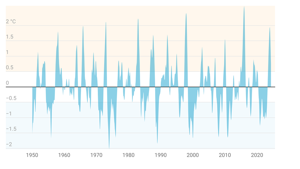
The chart shows the three-month rolling average temperature anomaly. (X‑axis is temperature, Y‑axis is Year)
Abnormality in Global Surface Temperature7
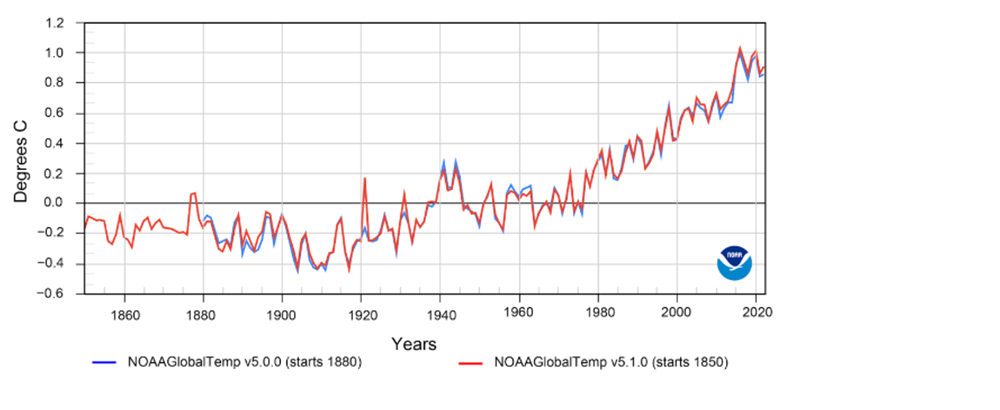
The El Niño episode of 1982‑1983 was the most devastating of the century, perhaps the worst in history. Perú was hit by the heaviest rainfall in history.
The major La Niña event in 1988‑1989 caused a severe drought that affected crops and water availability in the Southern portion of the continent.
Other extreme weather events, such as flooding and excessive rainfall, were caused by the 1996‑1997 El Niño.
At the end of 2014, the most intense El Niño on record began and lasted until the start of 2016. 2015 has been the warmest year on record, as shown in red in both graphs above. This was the strongest observed El Niño phenomenon for more than 15 years, affecting Latin America with notable consequences such as high level of precipitation in Argentina, northern Perú, and southern Chile.
Probably especially fresh in our memories is the most recent La Niña, which lasted for three years (2020‑2023) and generated droughts in South America that negatively impacted crops in Brazil, Argentina, Paraguay, and Uruguay.
More recently, the 2023‑2024 El Niño caused heat waves, wildfires, and floods in many parts of Latin America, highlighting the region’s vulnerability to these weather patterns. An approaching La Niña could further threaten the region’s infrastructure and agricultural strength, potentially leading an increase in the number of insurance claims.
Current probabilities issued by NOAA have turned out to be correct, and we are already seeing a La Niña phenomenon in action. The graph below demonstrates the predictions.
Official NOAA CPC ENSO Prohabilities (based on +/‑ 0.5ºC thresholds in ERSSTv5 Niño-3.4 index – issued August 2024)8
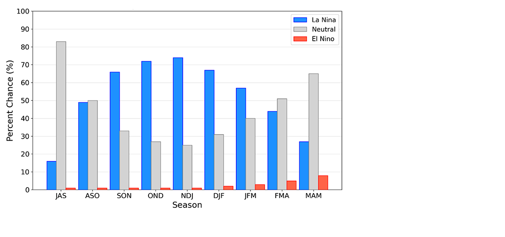
The snapshot below of a larger table9 shows warm (red) and cold (blue) periods in the Pacific Ocean based on a threshold of +/‑ 0.5ºC for the Oceanic Niño Index (ONI) for each three months running.
Cold & Warm Episodes by Season
|
Year |
DJF |
JFM |
FMA |
MAM |
AMJ |
MJJ |
JJA |
JAS |
ASO |
SON |
OND |
NDJ |
|---|---|---|---|---|---|---|---|---|---|---|---|---|
2020 |
0.5 |
0.5 |
0.4 |
0.2 |
-0.1 |
-0.3 |
-0.4 |
-0.6 |
-0.9 |
-1.2 |
-1.3 |
-1.2 |
2021 |
-1.0 |
-0.9 |
-0.8 |
-0.7 |
-0.5 |
-0.4 |
-0.4 |
-0.5 |
-0.7 |
-0.8 |
-1.0 |
-1.0 |
2022 |
-1.0 |
-0.9 |
-1.0 |
-1.1 |
-1.0 |
-0.9 |
-0.8 |
-0.9 |
-1.0 |
-1.0 |
-0.9 |
-0.8 |
2023 |
-0.7 |
-0.4 |
-0.1 |
0.2 |
0.5 |
0.8 |
1.1 |
1.3 |
1.6 |
1.8 |
1.9 |
2.0 |
2024 |
1.8 |
1.5 |
1.1 |
0.7 |
|
|
|
|
|
|
|
|
Effects and Impacts
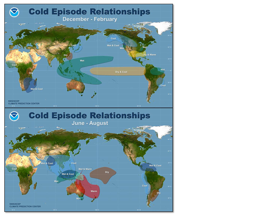
Expectations of a strong La Niña for 2024 include the following conditions and consequences:
The expectations include a reduction in rainfall over the central equatorial Pacific and areas of abnormally cold ocean surface temperatures. These patterns are responsible for many weather-related risks and are typical signs of La Niña. The rainfall pattern covers about half of the world and results in drier-than-normal conditions along coastal Ecuador, northwestern Peru, and equatorial eastern Africa during the December-January-February (DJF) months and over southern Brazil and central Argentina during June-July-August (JJA) months.10
With La Niña comes the expectation for notable departures from temperature averages. The regions affected by this phenomenon can expect cooler conditions.11
The graphic below describes the Walker Circulation. The Walker Circulation represents an atmospheric circulation or “loop” in which the lower portion of the loop flows from east to west across the majority of the tropical regions at the surface, while the upper portion of the loop flows from west to east at higher altitudes. The loop is connected by rising air flow in the west and sinking air flow in the east.
Walker Circulation12
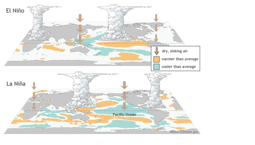
During La Niña, when the waters in the western Pacific exceed typical temperatures and the waters in the eastern Pacific reach below-average levels of warmth, this cooling is accompanied by alterations in the tropical air circulation, including modifications in wind patterns, air pressure, and rainfall. It increases the possibility of a stormier Atlantic hurricane season during La Niña and decreases it during El Niño in the Atlantic.13
Typical La Niña Influence
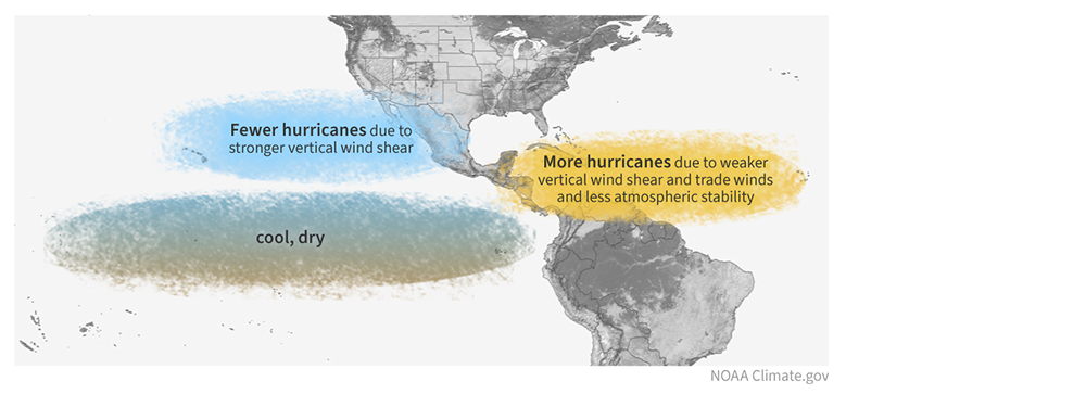
Typical El Niño Influence
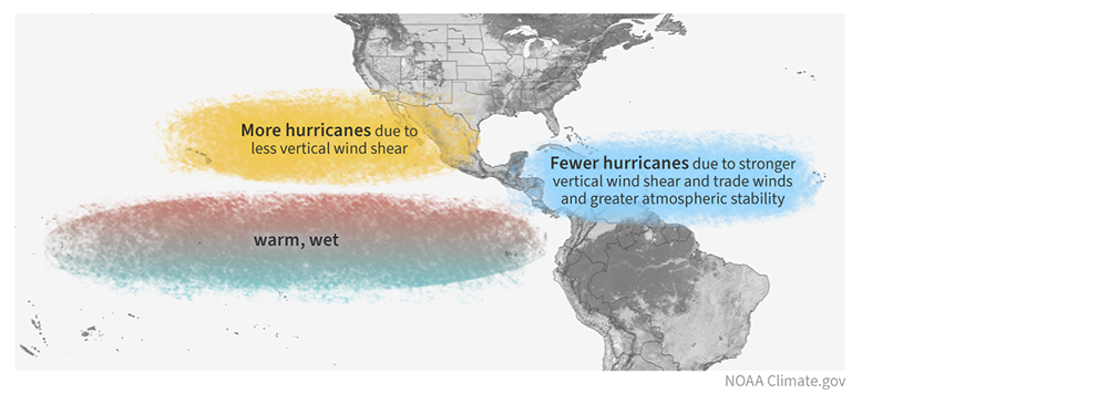
The 2024 Atlantic hurricane season started fiercely with category 5 Hurricane Beryl. Exceptionally warm ocean temperatures and an expected development of La Niña in the summer were the main factors contributing to NOAA’s prediction of a more active hurricane season in 2024.14
Conclusion
The complexity of the Earth’s atmosphere and the confluence of variable global climate factors to develop impactful weather events, such as hurricanes, droughts, excessive rainfalls, and wildfires, make it difficult to correlate the occurrence of El Niño or La Niña in a given year with specific impactful events. However, one can predict particular weather patterns given certain climatology characteristics. It is reasonable to assume that a warmer-than-normal Atlantic water mass, combined with a strong La Niña phenomenon, will result in an above-average Atlantic hurricane season in 2024, as several sources have already indicated. This is evidenced by the development of Hurricane Beryl at the end of June, and the potential for further disturbances in the Atlantic Ocean throughout the season.
To cope with the financial impact of such catastrophes, the insurance and reinsurance industry must be prepared, not only with risk-transfer products and more sophisticated models to predict and price the risks associated, but also with the ability to provide rapid payouts contingent on the event’s severity. As we experience stronger El Niño / La Niña phenomena, we should anticipate stronger and more impactful subsequent events such as busier hurricane seasons and/or record-breaking incidents initially considered secondary perils (e.g., floods, mudslides, droughts, and wildfires) that are now becoming primary concerns. These climate phenomena and their impacts on weather and weather events will require ongoing vigilance from those in the insurance and reinsurance industry.
- Rebecca Lindsey, “In Watching for El Niño and La Niña, NOAA Adapts to Global Warming”, NOAA, 5 Feb. 2013, https://www.climate.gov/news-features/understanding-climate/watching-el-ni%C3%B1o-and-la-ni%C3%B1a-noaa-adapts-global-warming.
- Ibid.
- Ibid.
- NOAA Climate Prediction Center, “El Niño and La Niña Ocean Temperature Patterns”: https://www.cpc.ncep.noaa.gov/products/analysis_monitoring/ensocycle/ensocycle.shtml.
- NOAA Climate Prediction Center, “The ENSO Cycle”, https://www.cpc.ncep.noaa.gov/products/analysis_monitoring/ensocycle/ensocycle.shtml.
- The Conversation “La Niña is coming, raising the chances of a dangerous Atlantic hurricane season – an atmospheric scientist explains this climate phenomenon”, https://theconversation.com/la-nina-is-coming-raising-the-chances-of-a-dangerous-atlantic-hurricane-season-an-atmospheric-scientist-explains-this-climate-phenomenon-228595.
- NOAA, National Centers for Environmental Information, “NOAA Updates its Global Surface Temperature Dataset”, https://www.ncei.noaa.gov/news/noaa-updates-its-global-surface-temperature-dataset. Reprinted with kind permission of NOAA.
- “ENSO Forecast”, Columbia Climate School, International Research Institute for Climate and Society, NOAA/CPC ENSO Forecast Graphic, courtesy of NOAA/CPC, https://iri.columbia.edu/our-expertise/climate/forecasts/enso/current/?enso_tab=enso-cpc_plume “Image provided by The International Research Institute for Climate and Society, Columbia University Climate School”: https://iri.columbia.edu/ENSO.
- “Cold and Warm Episodes by Season”, NOAA Climate Prediction Center, https://origin.cpc.ncep.noaa.gov/products/analysis_monitoring/ensostuff/ONI_v5.php. Reprinted with kind permission of NOAA.
- “La Niña – Related Rainfall Patterns Over The Tropical Pacific”, NOAA Climate Prediction Center, https://www.cpc.ncep.noaa.gov/products/analysis_monitoring/ensocycle/laninarain.shtml. Reprinted with kind permission of NOAA.
- “La Niña Related Global Temperature & Precipitation Patterns”, NOAA, Climate Prediction Center, https://www.cpc.ncep.noaa.gov/products/analysis_monitoring/ensocycle/laninasfc.shtml. Reprinted with kind permission of NOAA.
- Climate.gov, “El Niño & La Niña (El Niño-Southern Oscillation)”, https://www.climate.gov/enso. Reprinted with kind permission of NOAA.
- Ibid.
- Haley Thiem, “Category 5 Hurricane Beryl makes explosive start to 2024 Atlantic season”, NOAA, 3 July 2024, https://www.climate.gov/news-features/event-tracker/category-5-hurricane-beryl-makes-explosive-start-2024-atlantic-season.
All endnotes last accessed 14 August 2024.


